Manchester Waterway and Dry Run Remediation and Redevelopment
As part of their Senior Design Capstone course, Civil & Environmental Engineering students designed stormwater infrastructure to minimize flooding impacts in Manchester, particularly for structures newly identified as being in the floodplain after recent redrawing of maps.
In 2015, the Iowa Department of Natural Resources conducted a map update of the City’s waterways along the eastern portion of the City of Manchester. This revised study resulted in 239 new parcels being placed within the floodway or floodplain. The revised maps have raised several problems for homeowners. This ranged from reduced property values to having to purchase flood insurance when they were not required prior to the study being completed.
The Waterway and Dry Run Remediation and Redevelopment should look at cost/benefit analysis for ways to reduce the base flood elevations, removing/redeveloping properties located within the floodway, and redevelopment efforts for areas affected by buyouts and removals.
The student engineering team was tasked with minimizing flood risk and cost to the residents of Manchester. The updated FEMA flood maps showed that sections of the town are now at elevated flood risk relative to previous assessments. Increased flood risk impacted the community both directly (flooded structures) and indirectly (elevated flood insurance or reduced home values). Additionally, the impacted area was a relatively low-cost residential area, so displaced community members could be unable to relocate. To ensure public safety and minimize financial burden, the team worked with Manchester officials and engineers at Fehr Graham to reduce flood peaks and update storm infrastructure.
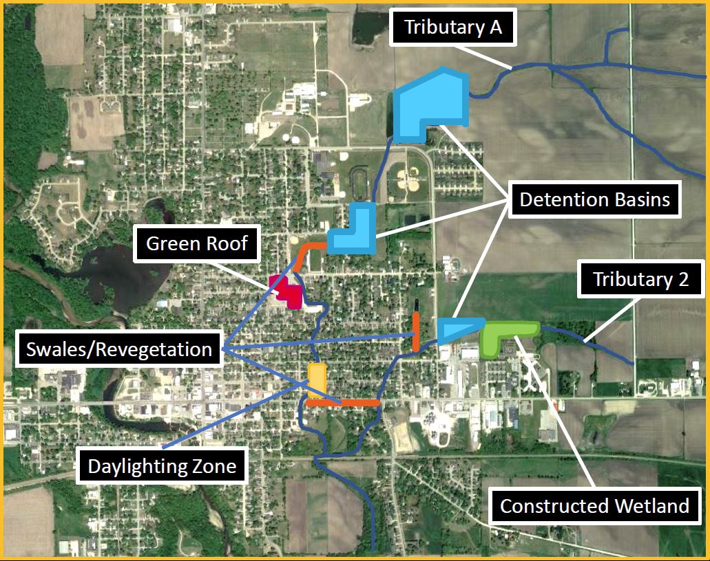
The primary aspect of the team's approach was creating detention basins to provide storage. This helped decrease flood peaks downstream by delaying the movement of water by creating more uniform flows. This approach required a large footprint, but it also minimized concerns for downstream impact and delayed the need for future upgrades.
Beyond the detention basins, the team included several recommendations for further investigation, including bioswales along Main Street and in city parks, a green roof design for West Delaware High School, and "daylighting" a buried channel so that flood potential is not magnified by choke points along the tributary. The daylighting recommendation considered the need to remove a handful of properties from the waterway. Designs and cost estimates were included in the final report.
Update from Manchester: "Using the concepts and planning identified in this project, we were able to focus on areas for future consideration of potential waterway and dry run remediation. This project piggybacked onto the City's pilot project of the meandering wetlands constructed on the eastern edge of the community. Within the wetlands project the City was able to obtain $219,000 in grants to construct the wetlands. Furthermore, the City of Manchester has been asked to partner in another pilot program, the Iowa Flood Coalition. Using this project and the partnership in the coalition, the City is hoping to be able to identify federal funding mechanisms to help address flooding and water quality issues along the waterway and dry runs along the eastern half of the city." (Spring 2024)
